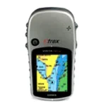
Description
A staple among outdoor enthusiasts, eTrex Summit HC features a high-sensitivity GPS receiver for peak performance in any environment and includes 24 megabytes (MB) of internal memory, a detailed basemap, crisp color screen, barometric altimeter and electronic compass.
Enjoy Clear Reception
With its high-sensitivity, WAAS-enabled GPS receiver, eTrex Summit HC locates your position quickly and precisely and maintains its GPS location even in heavy cover and deep canyons. The advantage is clear — whether you’re in deep woods or just near tall buildings and trees, you can count on Summit HC to help you find your way when you need it the most.
Get Your Bearings
eTrex Summit HC has a built-in electronic compass that provides bearing information even while you’re standing still, and its barometric altimeter tracks changes in pressure to pinpoint your precise altitude. You can even use the altimeter to plot barometric pressure over time, which can help you keep an eye on changing weather conditions.
Add More Detail
eTrex Summit HC’s basemap contains lakes, rivers, cities, interstates, national and state highways and coastlines. Summit HC also includes 24 MB of internal memory, so you can load waypoints and routes from the included MapSource® Trip & Waypoint Manager software and add map detail from Garmin’s entire line of optional MapSource® mapping products. Its 256-color, sunlight-readable display makes it easy to distinguish map details — even in bright sunlight.
eTrex Summit HC: Lock onto the great outdoors.
eTrex Summit HC
Basemap
MapSource® Trip & Waypoint Manager Software
USB cable
Wrist strap
Manuals